Showing posts with label Clouds. Show all posts

Tuesday, July 3, 2012

Wind Storm

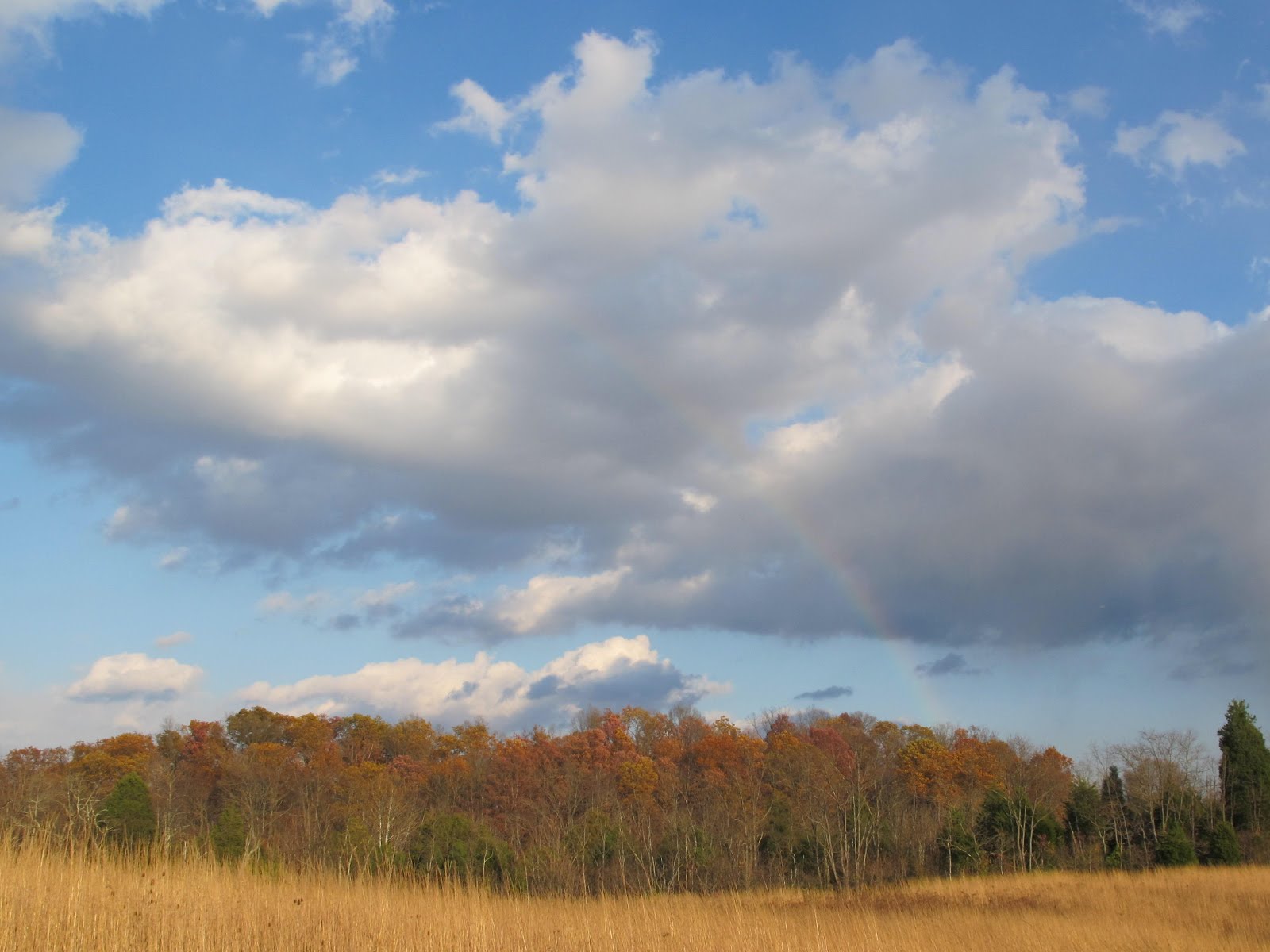
This is how the sky appeared in the wake of the storm that plowed over us on the evening of June 29. The colors are appropriate for the aftermath of a battle and the intensity of the storm certainly made you feel you had survived an attack. We spent a couple of days without electricity and a third day repairing our internet satellite link, but the lines have been repaired and we’re beginning to get back to normal. 

I’d been keeping an eye on the weather radar and it was not clear until the final hour that the storm was going to come our way.  I was trying to see if we might actually pick up some rain when the NWS reported a line of 80+ mph winds running about ten miles ahead of the rain band.  That meant the winds were almost upon us, so I went out to make sure things were as secure as possible.  There were no winds at the ground, but a long cloud suddenly arrowed over the hill from the north and shot over the barn.  I stopped to take two quick shots of the cloud and then put my camera back in its holster.  That’s when the surface wind clawed its way over the hill.  The trees 1,000 feet away looked like they were being torn to pieces.  I just made it to the back door as the wind slammed the house.

The trees in the yard looked like they’d been put into one of those machines that shakes the dead needles out of Christmas trees.  Dead branches were slung in all directions until caught by the wind and driven south.  Leaves left the trees like huge flocks of birds swirling together and shooting off into the sky.  The most curious thing was a Turkey Vulture gliding north into the wind as though nothing unusual was occurring.

The worst of the wind was through in about a minute.  Electricity was gone about 15 seconds after the wind hit, so my link to the weather radar was severed.  The following rain came through so fast that we got less than a tenth of an inch.

Following the rain, a gentle breeze brought air that was 25 degrees cooler than before.  After a quick check to make sure there wasn’t any immediate damage needing attention, I sat on the porch and enjoyed the sunset.  We’re only half way through the year and Blue Jay Barrens has already experienced floods, drought, hail, abnormally high temperatures and now a super wind storm.  I see a massive snow storm building for December.

Thursday, January 5, 2012

Snow

Blue Jay Barrens got its first snow of the season on January 2.  A total of two inches accumulated before noon and the rest of the day was a mix of wind, sun, clouds and snow showers.  You would have thought we were finally settling in to winter, if it weren’t for the predictions of a rapid warm-up back into the 50’s.

The flakes were large, but they were dry enough to settle down through the Indian Grass without sticking to the stalks.  There was enough warmth left in the ground to partially melt the snow and allow it to settle into a denser layer.

Ant mounds are always easy to see after a snow. Their snow cap will melt as soon as the sun emerges.

Snow on the ground makes it easy to view the trees and shrubs in the woodland understory.  The presence of a Sycamore on a steep slope is usually an indication of a wet weather spring.  These moisture loving trees can survive on the steep slope because of the added water provided by the spring.  The spring flow is often not enough to sustain a large tree, so the Sycamore will likely not grow to extreme proportions.

A snowy background provides the best conditions for illustrating the sprawling growth habit of the Fragrant Sumac.  The trunk of this low growing shrub may reach 20 feet long, but that length sprawls along the ground and drapes over other woodland shrubs.  In some situations this plant can become aggressive enough to displace other vegetation and produce a Fragrant Sumac monoculture.

New fallen snow always enhances the esthetic qualities of the creek.  I’m anxious for the snow to melt quickly, so the creek will be in shape to be beautified by the next new fallen snow.

Robins were busy digging in the wet leaves lining the creek and its tributaries.  I haven’t yet seen them gathered in large flocks.  Most groups contained around a dozen individuals.

The tall grass does a good job of hiding the snow, but it’s easy to see in the areas of sparse vegetative cover.  The afternoon skies showed a few patches of blue that gave the appearance of a pleasant day.  The strong wind and below freezing temperatures made you feel otherwise.

The clouds looked to be coming in as waves, but they were actually moving to the south in columns.  Each band stayed intact and moved quickly from right to left across the sky.  I could imagine the bands stretching all the way to Lake Michigan, which appears to have provided the moisture for this event.

Sunday, October 30, 2011

A Good Day

It was hard to tell from the weather forecast yesterday morning just what kind of day would unfold. I was hoping to collect some seed, but the plants need to be dry for that kind of activity. A heavy frost was still firmly in place at 9:00 am, so I knew it would probably be early afternoon before things dried off enough for seed harvest. The problem was a prediction of rain showers moving through in the afternoon. By mid-afternoon, things were bright, sunny and dry. The only problem was a series of small cloud clusters that brought with them a sprinkling of rain.


My primary objective was to collect some seed from the Tall Dropseed, Sporobolus asper. It would be a difficult plant to locate if it wasn’t for the mass of curly leaves that a clump of Tall Dropseed will produce.


It takes a bit of time to harvest the Tall Dropseed seed. The flower stalk and resulting seeds are hidden within a sheath near the top of the stalk. This means that you have to open the sheath to get to the seed. I’ve tried snapping the grass stem to harvest the seeds sheath and all, but the stem doesn’t want to break easily. It’s easier and faster to just unroll the sheath and strip the seeds into a collecting bucket.


I only got hit by one small shower and that one favored me with a rainbow as it passed. I was amazed that clouds so small could even produce rain, let alone enough to produce a rainbow.


The afternoon was quite peaceful and free of the typical noises of human activities. At one point, crows began to pass high overhead. It took about two minutes for the end of the string to go past.


The crows evidently had a need to get somewhere and soon disappeared out of sight. Their passing was completely silent. Not like the locals whose mouths seem to be activated by the flapping of their wings.


The departure of the crows left me with just my collection of seeds and some beautiful weather. I would have to say it was a good day.

Thursday, October 6, 2011

Sunset - SWF

Some people didn’t care much for look of yesterday’s green water, so today I thought I should provide something with more visual appeal. I never tire of the sunset view from The Hill and have a large collection of sky photos from that vantage point. Events occasionally conspire to produce a most spectacular scene.


The best conditions for a colorful display occur when heavy clouds are positioned to create a narrow gap on the horizon through which the sun’s rays can shine upward to reflect from the bottoms of the clouds. Clouds swirling around the back side of a low pressure system produce the best effects. On Monday evening, the low pressure system that plagued us with rain showers most of last week finally moved far enough east to pull away the last of our cloud blanket. The timing was perfect for a fantastic evening display.


I was concerned that the clouds might begin to break apart before the display was completed, but conditions held steady right through last light.


Part of the appeal of colorful sunsets is the unpredictability of the developing colors and patterns. Conditions change so quickly that diverting your gaze for a minute could cause you to miss the best of the show. While I’m photographing, I’m also taking the time to just relax and enjoy what’s happening before me. Photos never capture the essential beauty of a blazing sunset spread across the sky, but they can act as catalysts to rekindle that image in your mind.


Then come the fiery red glows that I had hoped for. A sunset similar to this one occurred almost exactly one year ago. People from across Southern Ohio commented on the intense colors and unusual patterns produced by that event. I wonder how far reaching this sky became.


There are only a few available minutes to run through the various color patterns before the light begins to disappear. The plants and animals of Blue Jay Barrens are unaffected by a pretty sunset. People might argue that the sunset has no practical management value toward the wellbeing of this property. I would have to disagree. A key ingredient in any land management effort is the attitude of the manager toward the property being managed. I have to admit that despite the color of the sunsets, I’m already committed to managing Blue Jay Barrens in what I feel is the best way in which to perpetuate the rare ecosystems found here. But to stand in the middle of what I’ve devoted so much of my life to achieve and view such a spectacular scene, helps to renew my emotional energy and increase my enthusiasm for the work to come. Passion is wonderful, but sometimes it helps to be revitalized by some small event. Blue Jay Barrens sunsets do that for me, so I can say with all certainty that they have a profound and necessary impact on this property.


A Skywatch Friday submission.

Friday, August 5, 2011

Storm Clouds - SWF

If yesterday’s topic was a little too bright for you, today’s post should help bring you back to normal. This has been a year of weather extremes. The drought of last fall carried almost through the winter. Spring was a time of excess rainfall and several violent storms. The start of summer coincided with the beginning of dry weather and things continued into a period of record heat. Instead of getting rain, Blue Jay Barrens has been a spawning ground for developing storms that have gone on to drench other areas. I was lucky enough to be on hand when this storm developed.


It’s exciting to watch storms form overhead. Instead of clouds moving in from some distant point, they appear and continue to expand in place. Scraps of cloud were moving in a dozen different directions as the mass rapidly filled the sky. Surface winds were just as unpredictable. A few seconds of wind to my face would suddenly be replaced by wind to my back and it kept changing every couple of seconds. The temperature changed just as frequently as the direction; first 90 degrees and then cold enough to give you shivers.


Weather isn’t just something that adds a touch of variety to conditions at Blue Jay Barrens. Weather patterns can have a significant and sometimes long lasting impact on plant and animal populations. The extremely wet spring has resulted in an excess of leaf growth on many of the perennial forbs. I assume that energy reserves are being replenished and root systems restored. This has been coupled with reduced flowering for many of these plants. With many species it’s stressful weather that triggers flower and fruit production, while good weather focuses the plant’s resources on improving it’s own condition.
I have to wonder how many people saw a face in this cloud. I sure did.


Studying current weather conditions can help me plan what activities I should expect to do this winter or next year. Drought retards the growth of many prairie plants. This makes conditions good during the winter for locating and removing unwanted cedars and other woody growth from the prairies. Wet years result in excellent growth the following spring, so that’s a perfect time to search for new species that may have gone unnoticed before.


The storm finally got organized and moved off to dump a couple of inches of rain on people about five miles away. I hope they appreciated the splendor of the clouds that Blue Jay Barrens had created for them. The churning black mass with little faux tornadoes dangling beneath should have sent everyone running for cover.

A Skywatch Friday submission

Tuesday, July 19, 2011

Clouds - July 25, 2005

I would like to think of Blue Jay Barrens as a self contained ecosystem functioning independently and isolated from the outside world. Of course, that’s not the case. Outside forces play a great role in shaping Blue Jay Barrens. Sometimes the outside effect is beneficial and other times it’s destructive. I see clouds as a reminder of those things that are absolutely outside of my control. Sometimes beautiful and other times frightening, clouds continually pass through the Blue Jay Barrens world. All I can do is observe and experience their passing.

NOTE: I’m away on a ten day excursion and have left the computer behind. So as not to have a ten day gap in posts, I’ve selected some of my favorite pictures from my pre-blogging days and set them up to automatically post one each day until I return. They may not be the best photo quality, but each identifies something of significance to me and to Blue Jay Barrens. I’ll continue my practice of current posts on July 27, 2011.

Thursday, October 7, 2010

Sunshine Returns (SWF)

Blue Jay Barrens has just come through four cool, cloudy, gray, drizzly days. I was really hoping to get some rain during the period, but the precipitation was never more than a heavy mist and our total accumulation over four days was just at 0.2 inches. On the evening of the fourth day open sky could be seen to the west between the horizon and the clouds. I headed up the hill to enjoy the few minutes of sunshine.

To the east, the setting sun showed that we were getting some color in the tree canopy. Of course, part of that color is the reflection from the clouds. Even the green leaves showed a touch of orange. The rapidly advancing shadows restricted the length of this show to about one minute.

The top of The Hill affords the best sky views and I often enjoy the show from up here. I enjoyed the view in the absence of any distractions. The wind stilled and for five minutes there was silence from all directions.

The large, double-trunked Tuliptree is like a kid begging to have the camera turned in his direction. The tree has already lost half of its leaves. This bareness makes the upper branches merge with the electric pink sky.

The clouds take on a menacing visage as the setting sun casts fire across the sky. These clouds represent the outer most band swirling around a low pressure system somewhere along the east coast. It’s unusual to have clouds moving out of the north and makes the whole scene even stranger.

As the light fades, I take one last shot and then head back down the hill. As I turn, I hear a Henslow’s Sparrow calling from the field. I’ve been futilely looking for Henslow’s all summer. Why do I finally hear one in October?
Check out Skywatch Friday for some magnificent sky images.